Article
From Confusion to Innovation
Demystifying Terminology to Harness Technology
Proliferation of Confusion
Alongside the explosion in data, there has been an overwhelming proliferation of data technologies often labelled and categorised using confusing and sometimes, misleading, terminology. From AI and big data to GeoAI and GeoParquet, there is now a whole new dictionary of terms that you - Marine Geospatial Innovators - now need to understand. Unfortunately, many terms carry multiple and often ambiguous meanings - leading to confusion, which erodes credibility, which reduces trust, and ultimately hinders our ability to truly harness the full potential of these technologies. For example, which would you rather implement, “an AI seabed feature identification technology” or “an seabed feature identification technology that uses ML”? Fundamentally, they’re the same thing.
This article aims to reduce the confusion so that you can better identify where these transformative technologies can help you innovate. To do this, this article first defines a few, but critical, general data technology terms; then dives a bit deeper into the terminology structure of artificial intelligence (AI); and finally explores how this all matters in the world of marine geospatial data through two specific examples.
Demystifying Terminology
To start, the definition of a few of the key general data related terms are provided the table below. By better understanding these terms, you will be able to better differentiate one technology from another and therefore, be more likely to identify where the opportunity exists to disrupt your market by implementing it.
As almost every modern and emerging data technology could be grouped under these terms, they can be thought of as pillars of a ‘data technology framework’. There is, of course, significant overlap between them and so, it's more of an interconnected data technology framework. The magic lies leveraging the core strengths of one, to get more out of another.
|
Technology |
Definition & Application |
|
Artificial Intelligence (AI) |
Artificial Intelligence or AI is the capability of technology (or a machine) to perform goal-directed adaptive behaviour [1]. Different types of AI are used to achieve this in different ways, including Robotic Process Automation (RPA); Machine Learning (ML); Agentic computing; Generative AI; and others continue to emerge. What can be achieved today ranges from task automation, through content generation and complex decision making, to avatars. AI, in effect, leverages all the other data technologies to deliver benefits across the entire spectrum from productivity, through revenue generation, to competitive differentiation. It enables the full potential of marine geospatial data to be harnessed. |
|
Big Data |
Big data encapsulates technologies developed to work with exceptional datasets across the data lifecycle. These datasets are exceptional as a result of their: volume, variety, velocity, veracity, and value. Big data technologies include everything from cloud data storage, through distributed computing frameworks and parallel data processing capabilities, to data visualisation. Example technologies include Apache Parquet, Apache Spark, and Juypter Notebooks. Big data technologies are an enabler of working with data at scale - whether that be in terms of sheer volume, complexity, or repeatability. In the same way that these technologies are foundational to AI, they will be foundational in revolutionising the way marine geospatial data is worked with. |
|
Cloud Services |
Cloud services is the delivery of computing services over the internet from a centralised location, to globally distributed consumers. In reality, the cloud is a datacentre (or network of datacentres) that holds the hardware and software resources to perform computing, that can be accessed remotely by consumers almost anywhere in the world. Cloud technologies are delivered ‘as-a-service’. For example, data-as-a-service, infrastructure-as-a-service, platform-as-a-service, and software-as-a-service. Cloud Services have enabled almost infinite scalability while dramatically reducing capital investment costs. This unlocks the ability to acquire, store, and compute limitless volumes of data; creating the opportunity to derive insights never before seen. |
|
Geospatial Information System (GIS) |
Geospatial Information System or GIS encapsulates all software technologies developed principally for application in the geospatial data lifecycle. Today, the term is most commonly associated with technologies for visualising geospatial data, such as ArcGIS, QGIS, and CARTO. However, in its broadest form, it also encapsulates technologies such as Google Earth, Ordinance Survey, CARIS, Kingdom, and SonarWiz. GIS technologies deliver reliable and integral models of our planet that underpin a vast array of human activity. The future generation of these technologies will be transformative in extracting even greater value out of marine geospatial data. |
Nesting Artificial Intelligence
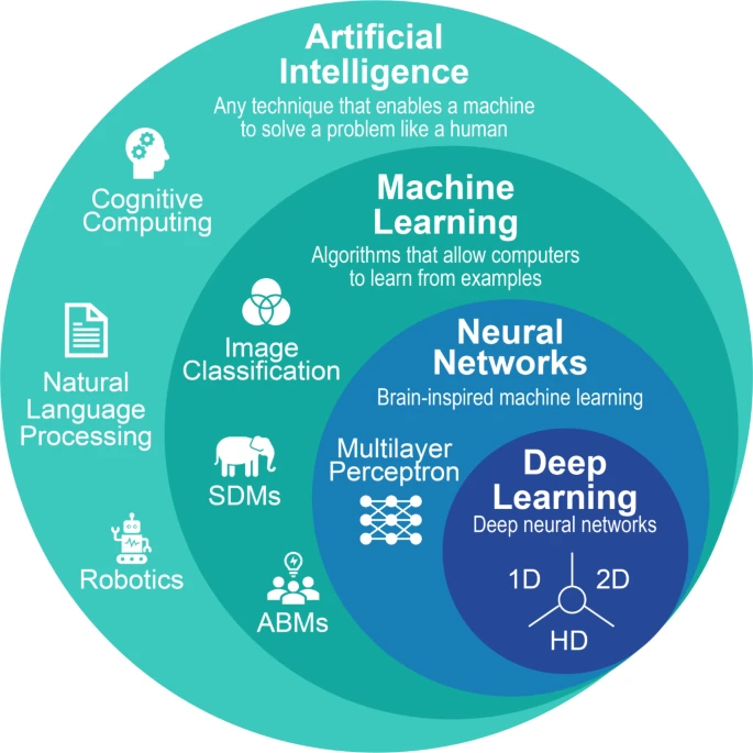
One source of significant confusion is that there are a multitude of terms associated with Artificial Intelligence (AI). Even the definition of AI in the table above refers to multiple terms. This makes it very difficult to know if a technology can be classed as AI, or if it’s something else trying to pass as AI. A very helpful way of understanding all these terms is illustrated in the nested hierarchy here [2].
With this understanding, it becomes evident why the term AI is so broadly used, yet at the same time, why it can be so confusing trying to understand the difference between machine learning (ML) and Deep Learning (DL). With this structure, you will be better able to refine what technologies can help you achieve your innovation goals.
Applying it to Marine Geospatial Data
Marine geospatial data is big data. It is vast in volume, comes from a variety of sources, needs to be of high veracity (or quality), is being acquired and is required at increasing velocity, and is of significant value. As a result, artificial intelligence (AI) and in particular, machine learning (ML), offers significant opportunities to revolutionise the way we work with marine geospatial data. Given the storage and compute resource demands required to enable this, cloud services are central to the technology landscape. When brought together, this new mix of modern and emerging technologies offers an opportunity to redefine the geospatial information system (GIS). To bring this to life with some specific examples.
Example 1: GeoParquet
Parquet is a data storage framework developed for big data. An offshoot of this framework has been adapted specifically to geospatial data, and is called GeoParquet. The most significant advantages of GeoParquet (and Parquet), is that data is stored in a much more efficient manner (i.e. it takes up far less storage space), and can be retrieved far quicker. One study showed a 4 - 6 times reduction in file size, and a ~4 times shorter file reading time [3]. Combined with cloud services, it means that you’re no longer constrained by data storage capacity or computing resources. So, the opportunity now becomes, what analysis can you do with all the marine geospatial data that you have?
Example 2: GeoAI
Machine learning (ML), a subset of AI, is used extensively to automate feature identification. ML can be thought of as training a person to perform a task or set of tasks - with the exception that this person excels at doing the same thing repeatedly; doesn’t ever need a break; and with cloud services, can be replicated as many times as you want at fractional costs. So, if you need someone to identify 30,000 boulders on the seabed in preparation for building an offshore windfarm, why wouldn’t you hire a company of ML replicas?
Wrapping Up
Data is now central to every decision, and this is being enabled by a proliferation of data technologies. To be able to use these technologies to their full potential, first requires a clear understanding of the terminology and their definitions. This article has identified a few of the most important terms and provided clear definitions for each; presented a nested hierarchy for AI and associated technologies; and outlined how this all relates to marine geospatial data through two specific examples. With this new knowledge, Aquallite Data hopes that you can start to, or expand your use of modern and emerging data technologies so that you can truly harness the full potential of your marine geospatial data.
Want to better understand even more terminology and acronyms?
References
- de Judicibus, D. (2015). The Definition of Intelligence. Definition of AI adapted from the definition of human intelligence presented by Sternberg, R.J. and Salter, W., 1982.
- Frazier, A.E. and Song, L. (2024). Artificial Intelligence in Landscape Ecology: Recent Advances, Perspectives, and Opportunities. Figure extracted is “Fg.1 The nested hierarchy of artificial intelligence (AI), machine learning (ML), …”.
- Graser, A. (2024). GeoParquet in QGIS - smaller & faster for the win! Basis of figures regarding benefits of GeoParquet.
- Wang, P. (2019). On Defining Artificial Intelligence. Used to inform AI definition, and other definitions presented herein.
- Dangermond, J. and Goodchild, M.F. (2020). Building geospatial infrastructure. Used to inform GIS and GeoAI definitions, and GeoAI example.